
پرونده:JerusalemFarWest1870s.jpg

پروندهٔ اصلی (۱٬۲۰۰ × ۸۹۸ پیکسل، اندازهٔ پرونده: ۴۴۱ کیلوبایت، نوع MIME پرونده: image/jpeg)
این پرونده در ویکیانبار موجود است. محتویات صفحهٔ توصیف آن در زیر نمایش داده میشود. |
خلاصه
| توضیح |
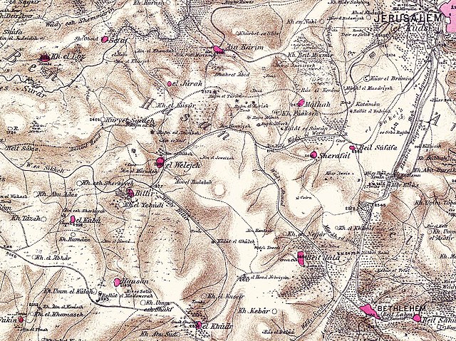
English: Region west of Jerusalem in the 1870s |
||||
| تاریخ | دههٔ 1870 | ||||
| منبع |
Palestine Exploration Fund map, sheet 17. Map of survey carried out between 1871 and 1878 by the Palestine Exploration Fund, published in 26 sections in 1880. |
||||
| پدیدآور | PEF | ||||
| اجازهنامه (استفادهٔ مجدد از این پرونده) |
|
||||
اجازهنامه
|
این اثر هنری دوبعدی که در این نگاره دیده میشود بخاطر تاریخ درگذشت پدیدآورنده آن یا تاریخ انتشارش هماکنون در سراسر جهان در مالکیت عمومی قرار دارد و استفاده از آن آزاد است.
بنابراین تکثیر آن در ایالات متحده آمریکا، آلمان و بسیاری کشورهای دیگر آزاد است.
| ||||
تاریخچهٔ پرونده
روی تاریخ/زمانها کلیک کنید تا نسخهٔ مربوط به آن هنگام را ببینید.
| تاریخ/زمان | بندانگشتی | ابعاد | کاربر | توضیح | |
|---|---|---|---|---|---|
| کنونی | ۲۰ آوریل ۲۰۱۰، ساعت ۱۳:۳۲ | | ۱٬۲۰۰ در ۸۹۸ (۴۴۱ کیلوبایت) | Zero0000 | {{Information |Description=Region west of Jerusalem in the 1870s |Source=Palestine Exploration Fund map, sheet 17. |Date=1870s |Author=PEF |Permission={{PD-old}} |other_versions= }} Category:Maps of Palestine in 19th century [[Category:Maps of Jerusa |
کاربرد پرونده
صفحهٔ زیر از این تصویر استفاده میکند:
کاربرد سراسری پرونده
ویکیهای دیگر زیر از این پرونده استفاده میکنند:
- کاربرد در ar.wikipedia.org
- کاربرد در arz.wikipedia.org
- کاربرد در az.wikipedia.org
- کاربرد در ca.wikipedia.org
- کاربرد در en.wikipedia.org
- کاربرد در es.wikipedia.org
- کاربرد در id.wikipedia.org
- کاربرد در nl.wikipedia.org
- کاربرد در no.wikipedia.org
- کاربرد در pl.wikipedia.org
- کاربرد در ur.wikipedia.org
- کاربرد در www.wikidata.org