
پرونده:CastelloPlanOriginal.jpg
پروندهٔ اصلی (۲٬۱۰۰ × ۱٬۳۹۸ پیکسل، اندازهٔ پرونده: ۳٫۲۸ مگابایت، نوع MIME پرونده: image/jpeg)
این پرونده در ویکیانبار موجود است. محتویات صفحهٔ توصیف آن در زیر نمایش داده میشود. |
خلاصه
| توضیح |
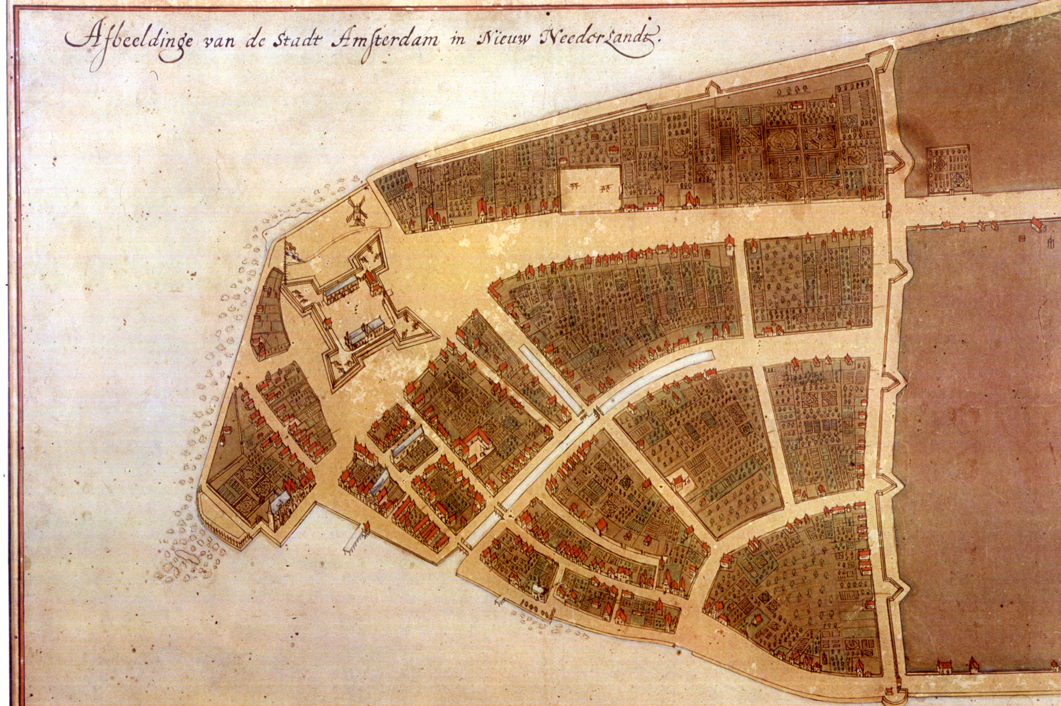
The original en:Castello Plan. Full size photograph of manuscript map in the Biblioteca Medicea-Laurenziana of Florence, Italy. The Castello plan is the earliest known plan of New Amsterdam (not Amsterdam, as you can see on the picture), and the only one dating from the Dutch period. The text at the top of the image states: "Image of the city Amsterdam in New Netherland". |
| تاریخ | |
| منبع | New York Public Library, Digital Gallery. Digital ID: 54682, Digital Record ID: 118555. |
| پدیدآور | Jacques Cortelyou, General Governor of Nieuw Amsterdam at that time. |
| دیگر نسخهها |
_Castello_Plan_1660.jpg)  |
اجازهنامه
|
این اثر هنری دوبعدی که در این نگاره دیده میشود بخاطر تاریخ درگذشت پدیدآورنده آن یا تاریخ انتشارش هماکنون در سراسر جهان در مالکیت عمومی قرار دارد و استفاده از آن آزاد است.
بنابراین تکثیر آن در ایالات متحده آمریکا، آلمان و بسیاری کشورهای دیگر آزاد است.
| ||||
| This image is available from the New York Public Library's Digital Library under the strucID 118555 This tag does not indicate the copyright status of the attached work. A normal copyright tag is still required. See Commons:Licensing for more information. |
.
تاریخچهٔ پرونده
روی تاریخ/زمانها کلیک کنید تا نسخهٔ مربوط به آن هنگام را ببینید.
| تاریخ/زمان | بندانگشتی | ابعاد | کاربر | توضیح | |
|---|---|---|---|---|---|
| کنونی | ۲۵ آوریل ۲۰۱۲، ساعت ۲۱:۱۶ | | ۲٬۱۰۰ در ۱٬۳۹۸ (۳٫۲۸ مگابایت) | Fentener van Vlissingen | higher resolution |
| ۹ ژوئیهٔ ۲۰۱۰، ساعت ۱۷:۰۵ |  | ۱٬۲۰۰ در ۹۰۵ (۱۸۰ کیلوبایت) | JuTa | higher resolution from de:Datei:Manhattan1.jpg uploaded by de:user:Nikater at 2006-07-13 14:31:26 local time | |
| ۱۲ اکتبر ۲۰۰۷، ساعت ۲۳:۰۷ |  | ۷۶۰ در ۵۶۹ (۳۵۵ کیلوبایت) | Hu Totya | {{Information |Description=The original en:Castello plan. Full size photograph of manuscript map in the Biblioteca Medicea-Laurenziana of Florence, Italy. The Castello plan is the earliest known plan of New Amsterdam, and the only one dating from the |
کاربرد پرونده
صفحهٔ زیر از این تصویر استفاده میکند:
کاربرد سراسری پرونده
ویکیهای دیگر زیر از این پرونده استفاده میکنند:
- کاربرد در ar.wikipedia.org
- کاربرد در arz.wikipedia.org
- کاربرد در azb.wikipedia.org
- کاربرد در cdo.wikipedia.org
- کاربرد در en.wikipedia.org
- کاربرد در es.wikibooks.org