
پرونده:Caledonides EN.svg

حجم پیشنمایش PNG این SVG file:۶۳۰ × ۴۲۱ پیکسل کیفیتهای دیگر: ۳۲۰ × ۲۱۴ پیکسل | ۶۴۰ × ۴۲۸ پیکسل | ۱٬۰۲۴ × ۶۸۴ پیکسل | ۱٬۲۸۰ × ۸۵۵ پیکسل | ۲٬۵۶۰ × ۱٬۷۱۱ پیکسل.
پروندهٔ اصلی (پروندهٔ اسویجی، با ابعاد ۶۳۰ × ۴۲۱ پیکسل، اندازهٔ پرونده: ۱۲۶ کیلوبایت)
این پرونده در ویکیانبار موجود است. محتویات صفحهٔ توصیف آن در زیر نمایش داده میشود. |
خلاصه
| توضیح |
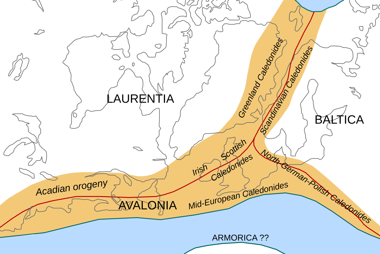
English: Location of the Caledonian/Acadian mountain chains in the Early Devonian Epoch. Present day coastlines are shown for reference. Red lines are sutures, capitalized names are the different continents/super-terranes that joined during the Caledonian orogeny. See en:Avalonia, en:Baltica, en:Laurentia.
Literature used to make this map:
|
| تاریخ | |
| منبع | اثر شخصی |
| پدیدآور | Woudloper |
| دیگر نسخهها |
آثار انشقاقی از این پرونده: |

|
این پروندهٔ اسویجی از متن جاسازیشده استفاده میکند که بهسادگی میتوان با این ابزار خودکار آن را به زبانتان ترجمه کرد (اطلاعات بیشتر).
همچنین میتوانید تصویر را دریافت و با یک ویرایشگر متن به طور دستی آن را ویرایش کنید. |
W3C-validity not checked.
اجازهنامه
این پرونده با اجازهنامهٔ کریتیو کامانز Attribution-Share Alike 1.0 عمومی منتشر شده است.
- شما اجازه دارید:
- برای به اشتراک گذاشتن – برای کپی، توزیع و انتقال اثر
- تلفیق کردن – برای انطباق اثر
- تحت شرایط زیر:
- انتساب – شما باید اعتبار مربوطه را به دست آورید، پیوندی به مجوز ارائه دهید و نشان دهید که آیا تغییرات ایجاد شدهاند یا خیر. شما ممکن است این کار را به هر روش منطقی انجام دهید، اما نه به هر شیوهای که پیشنهاد میکند که مجوزدهنده از شما یا استفادهتان حمایت کند.
- انتشار مشابه – If you alter, transform, or build upon this work, you must distribute the resulting work under the same license as the original.
تاریخچهٔ پرونده
روی تاریخ/زمانها کلیک کنید تا نسخهٔ مربوط به آن هنگام را ببینید.
| تاریخ/زمان | بندانگشتی | ابعاد | کاربر | توضیح | |
|---|---|---|---|---|---|
| کنونی | ۲۸ اکتبر ۲۰۰۸، ساعت ۱۰:۴۵ | | ۶۳۰ در ۴۲۱ (۱۲۶ کیلوبایت) | Woudloper | == Beschreibung == {{Information |Description={{en|1=Location of the Caledonian/Acadian mountain chains in the Early Devonian Epoch. Present day coastlines are shown for reference. Red lines are sutures, capitalized names are the different continents/supe |
| ۲۳ اکتبر ۲۰۰۸، ساعت ۰۹:۵۰ |  | ۶۳۰ در ۴۲۱ (۱۳۲ کیلوبایت) | Woudloper | == Beschreibung == {{Information |Description={{en|1=Location of the Caledonian/Acadian mountain chains in the Early Devonian Epoch. Present day coastlines are shown for reference. Red lines are sutures, capitalized names are the different continents/supe | |
| ۲۱ اکتبر ۲۰۰۸، ساعت ۱۵:۱۷ |  | ۶۳۰ در ۴۲۱ (۱۳۲ کیلوبایت) | Woudloper | {{Information |Description={{en|1=Location of the Caledonian/Acadian mountain chains in the Early Devonian Epoch. Present day coastlines are shown for reference. Red lines are sutures, capitalized names are the different continents/super-terranes that joi |
کاربرد پرونده
صفحهٔ زیر از این تصویر استفاده میکند:
کاربرد سراسری پرونده
ویکیهای دیگر زیر از این پرونده استفاده میکنند:
- کاربرد در az.wikipedia.org
- کاربرد در be-tarask.wikipedia.org
- کاربرد در be.wikipedia.org
- کاربرد در bg.wikipedia.org
- کاربرد در ca.wikipedia.org
- کاربرد در da.wikipedia.org
- کاربرد در en.wikipedia.org
- کاربرد در fr.wikipedia.org
- کاربرد در gl.wikipedia.org
- کاربرد در hy.wikipedia.org
- کاربرد در id.wikipedia.org
- کاربرد در it.wikipedia.org
- کاربرد در ja.wikipedia.org
- کاربرد در lv.wikipedia.org
- کاربرد در mk.wikipedia.org
- کاربرد در nl.wikipedia.org
- کاربرد در nn.wikipedia.org
- کاربرد در no.wikipedia.org
- کاربرد در pl.wikipedia.org
- کاربرد در ro.wikipedia.org
- کاربرد در ru.wikipedia.org
- کاربرد در simple.wikipedia.org
- کاربرد در sl.wikipedia.org
- کاربرد در tr.wikipedia.org
- کاربرد در uk.wikipedia.org
- کاربرد در vi.wikipedia.org
- کاربرد در zh.wikipedia.org