
پرونده:Baltic-Volga-Black-Caspian.png
تفکیکپذیری بالاتری در دسترس نیست.
Baltic-Volga-Black-Caspian.png (۳۴۰ × ۴۵۸ پیکسل، اندازهٔ پرونده: ۲۱۰ کیلوبایت، نوع MIME پرونده: image/png)
این پرونده در ویکیانبار موجود است. محتویات صفحهٔ توصیف آن در زیر نمایش داده میشود. |
خلاصه
| توضیح |
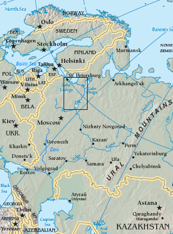
English: Map of the Volga–Baltic Waterway (boxed area).
source map modified with additional labels, box source map modified with additional labels, line drawing, box Original map cropped from https://www.cia.gov/cia/publications/factbook/reference_maps/asia.html |
| تاریخ | ۲۹ اوت ۲۰۰۶ (تاریخ اصلی بارگذاری) |
| منبع | Transferred from en.wikipedia to Commons. |
| پدیدآور | The original uploader was Jauntymcd در ویکیپدیا انگلیسی. |
اجازهنامه
This image is in the public domain because it contains materials that originally came from the United States Central Intelligence Agency's World Factbook.
|
 |
This work is based on a work in the public domain. It has been digitally enhanced and/or modified. This derivative work has been (or is hereby) released into the public domain by its author, jauntymcd. This applies worldwide.
In some countries this may not be legally possible; if so: |
سیاهه بارگذاری اصلی
صفحهٔ اصلی توضیحات اینجابود. همهٔ نامهای کاربر زیر به en.wikipedia اشاره دارند.
- 2006-08-29 23:28 Jauntymcd 340×458×8 (214664 bytes) source map modified with additional labels, box source map modified with additional labels, line drawing, box {{PD-retouched-user|jauntymcd}} Original map cropped from https://www.cia.gov/cia/publications/factbook/reference_maps/asia.html {{PD-USGov-CIA-
تاریخچهٔ پرونده
روی تاریخ/زمانها کلیک کنید تا نسخهٔ مربوط به آن هنگام را ببینید.
| تاریخ/زمان | بندانگشتی | ابعاد | کاربر | توضیح | |
|---|---|---|---|---|---|
| کنونی | ۱۹ دسامبر ۲۰۰۷، ساعت ۰۱:۳۲ | | ۳۴۰ در ۴۵۸ (۲۱۰ کیلوبایت) | Geanixx | {{Information |Description={{en|source map modified with additional labels, box source map modified with additional labels, line drawing, box Original map cropped from https://www.cia.gov/cia/publications/factbook/reference_maps/asia.html}} |Source=Tran |
کاربرد پرونده
صفحهٔ زیر از این تصویر استفاده میکند:
کاربرد سراسری پرونده
ویکیهای دیگر زیر از این پرونده استفاده میکنند:
- کاربرد در da.wikipedia.org
- کاربرد در en.wikipedia.org
- کاربرد در eo.wikipedia.org
- کاربرد در es.wikipedia.org
- کاربرد در eu.wikipedia.org
- کاربرد در he.wikipedia.org
- کاربرد در it.wikipedia.org
- کاربرد در ja.wikipedia.org
- کاربرد در nn.wikipedia.org
- کاربرد در no.wikipedia.org
- کاربرد در pl.wikipedia.org
- کاربرد در sl.wikipedia.org
- کاربرد در uz.wikipedia.org
- کاربرد در zh-yue.wikipedia.org
- کاربرد در zh.wikipedia.org