
پرونده:1686 Mallet Map of Ceylon or Sri Lanka (Taprobane) - Geographicus - Taprobane-mallet-1686.jpg

اندازهٔ این پیشنمایش: ۴۷۲ × ۵۹۹ پیکسل. کیفیتهای دیگر: ۱۸۹ × ۲۴۰ پیکسل | ۳۷۸ × ۴۸۰ پیکسل | ۶۰۵ × ۷۶۸ پیکسل | ۸۰۷ × ۱٬۰۲۴ پیکسل | ۱٬۶۰۲ × ۲٬۰۳۳ پیکسل.
پروندهٔ اصلی (۱٬۶۰۲ × ۲٬۰۳۳ پیکسل، اندازهٔ پرونده: ۱ مگابایت، نوع MIME پرونده: image/jpeg)
این پرونده در ویکیانبار موجود است. محتویات صفحهٔ توصیف آن در زیر نمایش داده میشود. |
_-_Geographicus_-_Taprobane-mallet-1686.jpg?uselang=fa)
| Ancienne Isle Taprobane. Die alte Insel Tabrobane. | ||||||
|---|---|---|---|---|---|---|
| هنرمند | ||||||
| عنوان |
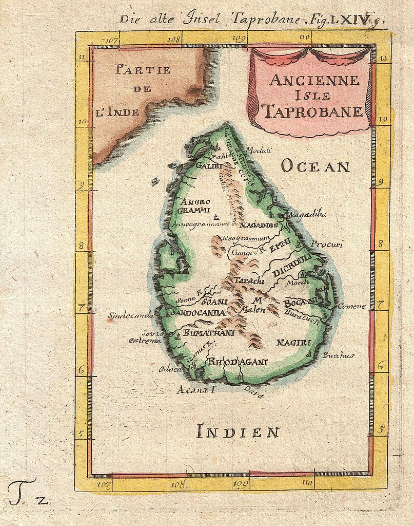
Ancienne Isle Taprobane. Die alte Insel Tabrobane. |
|||||
| توضیح |
English: A beautiful miniature 1683 map of Ceylon, Sri Lanka, or Taprobane by Alain Mallet. This stunning little map covers the island of Ceylon as well as parts of adjacent India. Mallet first introduced this map in the 1683 though it was republished several time in the subsequent 20 years. Taprobane is an ancient name for a spice rich trading center that was well known in ancient Roman times. By the 17th century Portuguese explorers had reopened the route to the Indies but were uncertain exactly which island the Romans were referring to. Some map Taprobrane as Sumatra, other as Ceylon. The common consensus now, as in Mallet’s time, is that the Roman Taprobane is Ceylon. Published by copper plate in the 1686 Frankfurt edition of Mallet’s Description de l'Univers. |
|||||
| تاریخ | ۱۶۸۶ (undated) | |||||
| ابعاد | بلندی: ۷٫۰ اینچ (۱۷٫۷ سانتیمتر)؛ عرض: ۵٫۰ اینچ (۱۲٫۷ سانتیمتر) | |||||
| آیدی |
Geographicus link: Taprobane-mallet-1686 |
|||||
| منبع/عکاس |
Mallet, A., Description de l'Univers, (Frankfurt), 1686.
|
|||||
| اجازهنامه (استفادهٔ مجدد از این پرونده) |
|
|||||
تاریخچهٔ پرونده
روی تاریخ/زمانها کلیک کنید تا نسخهٔ مربوط به آن هنگام را ببینید.
| تاریخ/زمان | بندانگشتی | ابعاد | کاربر | توضیح | |
|---|---|---|---|---|---|
| کنونی | ۲۴ مارس ۲۰۱۱، ساعت ۲۲:۱۷ | | ۱٬۶۰۲ در ۲٬۰۳۳ (۱ مگابایت) | BotMultichillT | {{subst:User:Multichill/Geographicus |link=http://www.geographicus.com/P/AntiqueMap/Taprobane-mallet-1686 |product_name=1686 Mallet Map of Ceylon or Sri Lanka (Taprobane) |map_title=Ancienne Isle Taprobane. Die alte Insel Tabrobane. |description=A beautif |
کاربرد پرونده
صفحهٔ زیر از این تصویر استفاده میکند:
کاربرد سراسری پرونده
ویکیهای دیگر زیر از این پرونده استفاده میکنند:
- کاربرد در ar.wikipedia.org
- کاربرد در ckb.wikipedia.org
- کاربرد در en.wikipedia.org
- History of Sri Lanka
- Mahāvaṃsa
- Beminitiya Seya
- Cūḷavaṃsa
- Sri Lankan independence movement
- Dīpavaṃsa
- Template:History of Sri Lanka
- Capital of Sri Lanka
- Prehistory of Sri Lanka
- User:Blackknight12/List of historical Sri Lankan overseas military operations
- History of Sri Lanka (1948–present)
- Anuradhapura period
- Chola conquest of Anuradhapura
- User:༆/History of Asia templates
- User:Blackknight12/sandbox
- List of wars involving Sri Lanka
- Pre-Anuradhapura period
- Polonnaruwa period
- Transitional period of Sri Lanka
- Rajavaliya
- Kandyan period
- Crisis of the Sixteenth Century
- Template:History of Sri Lanka/doc
- Malay invasions of Sri Lanka
- Cartography of Sri Lanka
- User:Lesa2006/sandbox
- کاربرد در fi.wikipedia.org
- کاربرد در fr.wikipedia.org
- کاربرد در ja.wikipedia.org
- کاربرد در km.wikipedia.org
- کاربرد در ko.wikipedia.org
نمایش استفادههای سراسری از این پرونده.
_-_Geographicus_-_Taprobane-mallet-1686.jpg)
_-_Geographicus_-_Taprobane-mallet-1686.jpg)