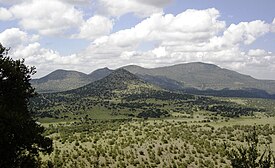
کوههای دیویس
| کوههای دیویس | |
|---|---|
 Davis Mountains | |
 | |
| مرتفعترین نقطه | |
| قله | Baldy Peak atop Mount Livermore |
| ارتفاع | ۸٬۳۷۸ پا (۲۵۵۴ متر) |
| جغرافیا | |
| کشور | ایالات متحده آمریکا |
| ایالت | تگزاس |
| زمینشناسی | |
| سن صخره | پالئوژن |
| نوع صخره | سنگ آذرین |
کوههای دیویس (به انگلیسی: Davis Mountains) رشته کوهی است در غرب تگزاس در قاره آمریکای شمالی.[۱]
این کوهها بخشی از کوههای راکی جنوبی بوده و بلندترین قلهٔ آن قله لیورمور (۲۵۵۵ متر) نام دارد.
رصدخانه مکدونالد در این کوهها قرار دارند.
منابع[ویرایش]
| در ویکیانبار پروندههایی دربارهٔ کوههای دیویس موجود است. |
