
پرونده:SAC - FAA airport diagram.png
اندازهٔ این پیشنمایش: ۳۹۰ × ۵۹۹ پیکسل. کیفیتهای دیگر: ۱۵۶ × ۲۴۰ پیکسل | ۳۱۳ × ۴۸۰ پیکسل | ۸۰۶ × ۱٬۲۳۷ پیکسل.
پروندهٔ اصلی (۸۰۶ × ۱٬۲۳۷ پیکسل، اندازهٔ پرونده: ۴۶ کیلوبایت، نوع MIME پرونده: image/png)
این پرونده در ویکیانبار موجود است. محتویات صفحهٔ توصیف آن در زیر نمایش داده میشود. |
خلاصه
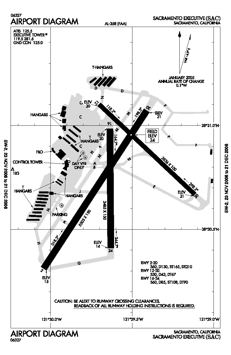
| توضیح | Out-Of-Date FAA airport diagram for SAC (Sacramento Executive Airport) in California, United States. Runway 16/34 has been permanently closed and demolished as of January 2022. |
| تاریخ | تاریخ نامعلوم. Effective: 23 November 2006 - 21 December 2006 |
| منبع | http://www.naco.faa.gov/index.asp?xml=naco/online/d_tpp |
| پدیدآور | United States Federal Aviation Administration |
| اجازهنامه (استفادهٔ مجدد از این پرونده) |
Public Domain |
اجازهنامه
This image or file is a work of a Federal Aviation Administration employee, taken or made as part of that person's official duties. As a work of the U.S. federal government, the image is in the public domain in the United States.
|
 |
تاریخچهٔ پرونده
روی تاریخ/زمانها کلیک کنید تا نسخهٔ مربوط به آن هنگام را ببینید.
| تاریخ/زمان | بندانگشتی | ابعاد | کاربر | توضیح | |
|---|---|---|---|---|---|
| کنونی | ۴ دسامبر ۲۰۰۶، ساعت ۲۲:۱۴ | | ۸۰۶ در ۱٬۲۳۷ (۴۶ کیلوبایت) | Thadius856 | == Summary == {{Information| |Description = FAA airport diagram for SAC (Sacramento Executive Airport) in California, United States. |Source = http://www.naco.faa.gov/index.asp?xml=naco/online/d_tpp |Date = Unknown. Effective: 23 November 2006 - 21 Decemb |
کاربرد پرونده
صفحهٔ زیر از این تصویر استفاده میکند:
کاربرد سراسری پرونده
ویکیهای دیگر زیر از این پرونده استفاده میکنند:
- کاربرد در en.wikipedia.org
- کاربرد در tg.wikipedia.org