
پرونده:Persia 1814.jpg
اندازهٔ این پیشنمایش: ۷۱۸ × ۶۰۰ پیکسل. کیفیتهای دیگر: ۲۸۷ × ۲۴۰ پیکسل | ۵۷۵ × ۴۸۰ پیکسل | ۹۲۰ × ۷۶۸ پیکسل | ۱٬۲۲۶ × ۱٬۰۲۴ پیکسل | ۲٬۴۵۲ × ۲٬۰۴۸ پیکسل | ۲٬۹۳۱ × ۲٬۴۴۸ پیکسل.
پروندهٔ اصلی (۲٬۹۳۱ × ۲٬۴۴۸ پیکسل، اندازهٔ پرونده: ۱٫۶ مگابایت، نوع MIME پرونده: image/jpeg)
این پرونده در ویکیانبار موجود است. محتویات صفحهٔ توصیف آن در زیر نمایش داده میشود. |
خلاصه
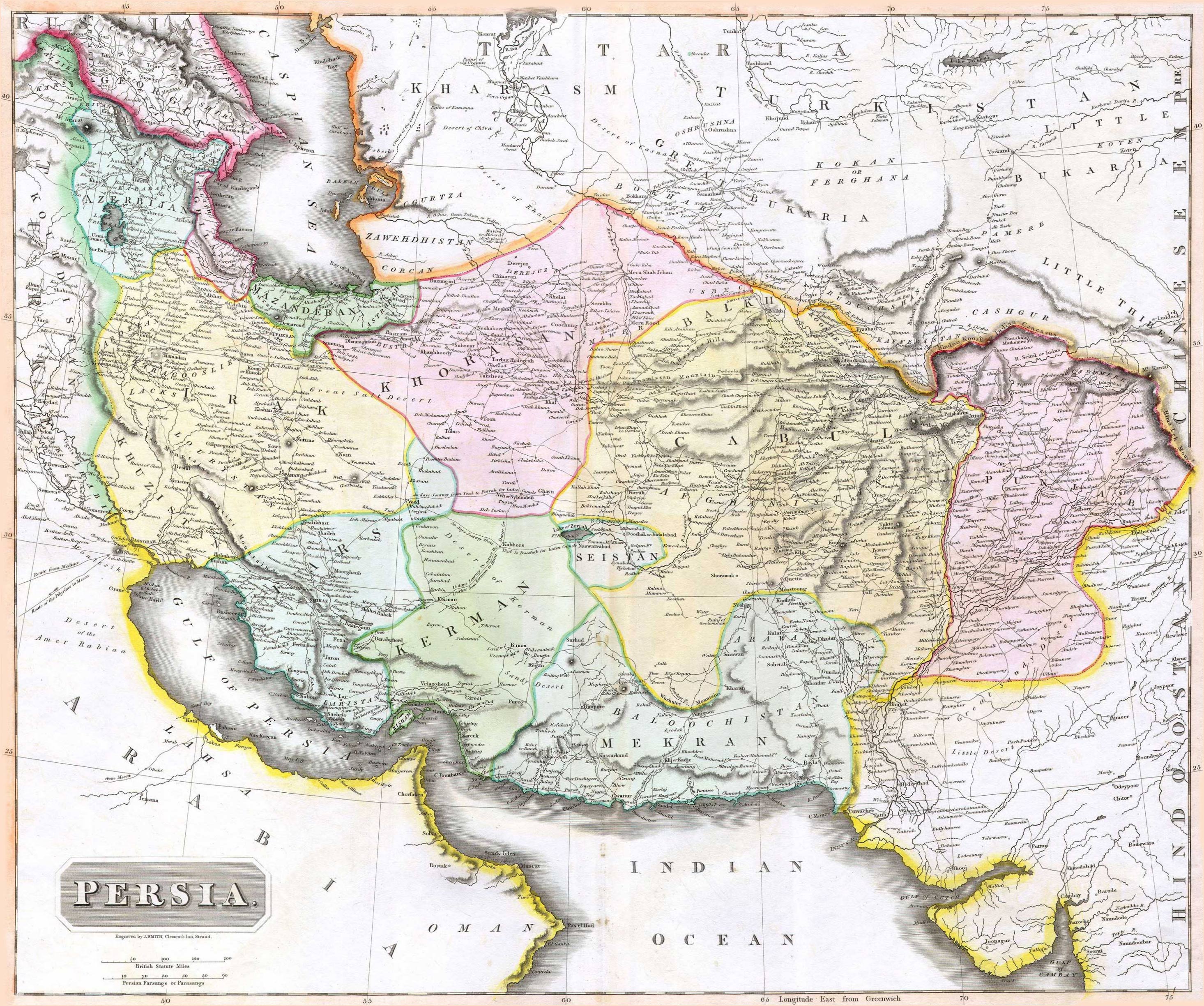
| Description |
English: 1814 Thomson Map of Persia (Iran), engraved by J. Smith, Clement's Inn, Strand. |
| تاریخ | |
| پدیدآورنده |
J. Smith, Clement's Inn, Strand. |
| Geotemporal data | |
| Map location | Iran |
| Georeferencing | If inappropriate please set warp_status = skip to hide. |
| Bibliographic data | |
| چاپخانه |
New General Atlas (1821) |
| پدیدآور |
John Thomson |
| دیگر نسخهها | |

اجازهنامه
The copyright situation of this work is theoretically uncertain, because in the country of origin copyright lasts 70 years after the death of the author, and the date of the author's death is unknown. However, the date of creation of the work was over 120 years ago, and it is thus a reasonable assumption that the copyright has expired (see here for the community discussion). Do not use this template if the date of death of the author is known.
این اثر در ایالات متحده آمریکا در مالکیت عمومی قرار دارد به این دلیل که قبل از ۱ ژانویهٔ ۱۹۲۹ منتشر یا در ادارهٔ حق تکثیر آمریکا ثبت شدهاست. | |
| این پرونده تحت قانون حق تکثیر محدودیت آزاد منتشر شده که شامل تمامی حقوق مربوطه و حقوق نزدیک به آن میشود. | |
تاریخچهٔ پرونده
روی تاریخ/زمانها کلیک کنید تا نسخهٔ مربوط به آن هنگام را ببینید.
| تاریخ/زمان | بندانگشتی | ابعاد | کاربر | توضیح | |
|---|---|---|---|---|---|
| کنونی | ۱۸ اوت ۲۰۱۰، ساعت ۰۷:۲۷ | | ۲٬۹۳۱ در ۲٬۴۴۸ (۱٫۶ مگابایت) | Begoon | edge perspective and crop |
| ۱۹ نوامبر ۲۰۰۶، ساعت ۰۲:۳۵ |  | ۲٬۹۷۹ در ۲٬۵۲۰ (۱٫۴۵ مگابایت) | Kaveh | == Summary == 1814 Thomson Map of Persia (Iran) Category:Maps of Iran == Licensing == {{PD-old}} |
کاربرد پرونده
صفحههای زیر از این تصویر استفاده میکنند:
کاربرد سراسری پرونده
ویکیهای دیگر زیر از این پرونده استفاده میکنند:
- کاربرد در ar.wikipedia.org
- کاربرد در az.wikipedia.org
- کاربرد در be.wikipedia.org
- کاربرد در bn.wikipedia.org
- کاربرد در bs.wikipedia.org
- کاربرد در ca.wikipedia.org
- کاربرد در da.wikipedia.org
- کاربرد در de.wikipedia.org
- کاربرد در en.wikipedia.org
- کاربرد در es.wikipedia.org
- کاربرد در eu.wikipedia.org
- کاربرد در fr.wikipedia.org
- کاربرد در hi.wikipedia.org
- کاربرد در hr.wikipedia.org
- کاربرد در hu.wikipedia.org
- کاربرد در hy.wikipedia.org
- کاربرد در incubator.wikimedia.org
- کاربرد در it.wikipedia.org
- کاربرد در ja.wikipedia.org
- کاربرد در ko.wikipedia.org
- کاربرد در la.wikipedia.org
- کاربرد در mk.wikipedia.org
- کاربرد در pl.wikipedia.org
- کاربرد در pnb.wikipedia.org
نمایش استفادههای سراسری از این پرونده.