
پرونده:Azores old map.jpg

پروندهٔ اصلی (۲٬۱۰۴ × ۱٬۴۸۰ پیکسل، اندازهٔ پرونده: ۶۷۸ کیلوبایت، نوع MIME پرونده: image/jpeg)
این پرونده در ویکیانبار موجود است. محتویات صفحهٔ توصیف آن در زیر نمایش داده میشود. |
خلاصه

|
این old map نگاره میبایست با استفاده از گرافیک برداری اسویجی فایل بازسازی شوند. این چند مزیت دارد؛ Commons:Media for cleanup را برای اطلاعات بیشتر ببینید. اگر حالت برداری آن در حال حاضر موجود است، لطفاً آن را بار کنید. پس از بارکردن یک اسویجی، این الگو را با {{vector version available|new image name.svg}} جایگزین کنید.
|


| توضیح |
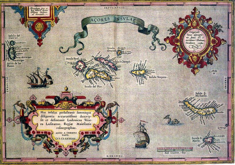
English: Sixteenth-century map of Azores. Legend, in Latin: "Has insulas perlustrauit summàque diligentia accuratissimè descripsit et delineauit Ludovicus Teisera Lusitanus, Regiæ Maiestatis cosmographus. ANNO A CHRISTO NATO, M.D.LXXXIIII" ("These islands were illustrated and described with great diligence and drawn by the Portuguese Luís Teixeira, his royal majesty's cartographer, AD 1584.") Deutsch: alte Karte der Azoren Português: "Açores Insulae" ("Ilhas dos Açores"), Luís Teixeira, c. 1584. A legenda, em latim - "Has insulas perlustrauit summàque diligentia accuratissimè descripsit et delineauit Ludovicus Teisera Lusitanus, Regiæ Maiestatis cosmographus. ANNO A CHRISTO NATO, M.D.LXXXIIII" -, pode ser traduzida livremente como: "Estas ilhas foram percorridas com a maior diligência, e com todo o cuidado as descreveu o português Luís Teixeira, cosmógrafo da Majestade Real. Ano do nascimento de Cristo de 1584." |
| تاریخ | |
| منبع | see above |
| پدیدآور | Abraham Ortelius |
اجازهنامه
|
این اثر هنری دوبعدی که در این نگاره دیده میشود بخاطر تاریخ درگذشت پدیدآورنده آن یا تاریخ انتشارش هماکنون در سراسر جهان در مالکیت عمومی قرار دارد و استفاده از آن آزاد است.
بنابراین تکثیر آن در ایالات متحده آمریکا، آلمان و بسیاری کشورهای دیگر آزاد است. {{PD-Art}} template without license parameter: please specify why the underlying work is public domain in both the source country and the United States
(Usage: {{PD-Art|1=|deathyear=''year of author's death''|country=''source country''}}, where parameter #1 can be PD-old-auto, PD-old-auto-expired, PD-old-auto-1996, PD-old-100 or similar. See Commons:Multi-license copyright tags for more information.) | ||||
تاریخچهٔ پرونده
روی تاریخ/زمانها کلیک کنید تا نسخهٔ مربوط به آن هنگام را ببینید.
| تاریخ/زمان | بندانگشتی | ابعاد | کاربر | توضیح | |
|---|---|---|---|---|---|
| کنونی | ۱۷ ژوئیهٔ ۲۰۰۵، ساعت ۰۶:۵۹ | | ۲٬۱۰۴ در ۱٬۴۸۰ (۶۷۸ کیلوبایت) | Nataraja~commonswiki | |
| ۱۷ ژوئیهٔ ۲۰۰۵، ساعت ۰۲:۱۶ |  | ۲٬۱۰۴ در ۱٬۴۸۰ (۶۳۵ کیلوبایت) | Angrense | Abraham Ortelius map of the Azores (c. 1585). {{PD}} Category:Azores |
کاربرد پرونده
صفحهٔ زیر از این تصویر استفاده میکند:
کاربرد سراسری پرونده
ویکیهای دیگر زیر از این پرونده استفاده میکنند:
- کاربرد در als.wikipedia.org
- کاربرد در an.wikipedia.org
- کاربرد در ca.wikipedia.org
- کاربرد در da.wikipedia.org
- کاربرد در de.wikipedia.org
- کاربرد در el.wikipedia.org
- کاربرد در en.wikipedia.org
- کاربرد در eo.wikipedia.org
- کاربرد در es.wikipedia.org
- کاربرد در fi.wikipedia.org
- کاربرد در fr.wikipedia.org
- کاربرد در gl.wikipedia.org
- کاربرد در id.wikipedia.org
- کاربرد در is.wikipedia.org
- کاربرد در it.wikipedia.org
- کاربرد در la.wikipedia.org
- کاربرد در mk.wikipedia.org
- کاربرد در nds-nl.wikipedia.org
- کاربرد در nn.wikipedia.org
- کاربرد در no.wikipedia.org
- کاربرد در pt.wikipedia.org
- کاربرد در ru.wikipedia.org
- کاربرد در sh.wikipedia.org
- کاربرد در sk.wikipedia.org
نمایش استفادههای سراسری از این پرونده.