
پرونده:1730 Ottens Map of Persia (Iran, Iraq, Turkey) - Geographicus - RegnumPersicum-ottens-1730.jpg
اندازهٔ این پیشنمایش: ۸۰۰ × ۴۵۵ پیکسل. کیفیتهای دیگر: ۳۲۰ × ۱۸۲ پیکسل | ۶۴۰ × ۳۶۴ پیکسل | ۱٬۰۲۴ × ۵۸۳ پیکسل | ۱٬۲۸۰ × ۷۲۸ پیکسل | ۲٬۵۶۰ × ۱٬۴۵۷ پیکسل | ۵٬۰۰۰ × ۲٬۸۴۵ پیکسل.
پروندهٔ اصلی (۵٬۰۰۰ × ۲٬۸۴۵ پیکسل، اندازهٔ پرونده: ۳٫۶ مگابایت، نوع MIME پرونده: image/jpeg)
این پرونده در ویکیانبار موجود است. محتویات صفحهٔ توصیف آن در زیر نمایش داده میشود. |
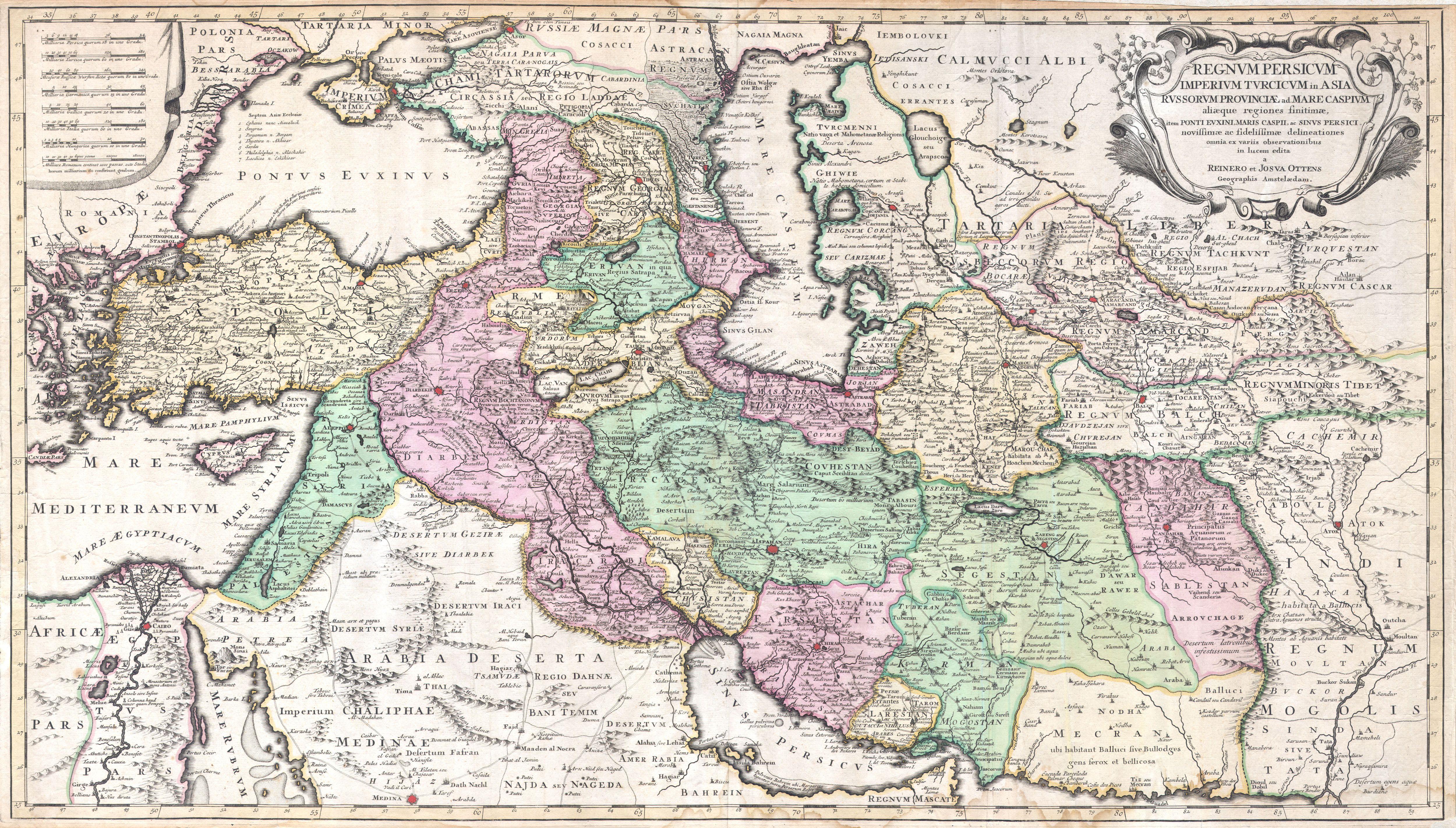
| Regnum Persicum Imperium Turcicum in Asia Russorum Provinciae and Mare Caspium. | ||||||
|---|---|---|---|---|---|---|
| هنرمند | ||||||
| عنوان |
Regnum Persicum Imperium Turcicum in Asia Russorum Provinciae and Mare Caspium. |
|||||
| توضیح |
English: A scarce and altogether spectacular c. 1730 map of southwestern Asia, specifically focusing on Persia, by Reiner and Joshua Ottens. Covers from Egypt and Greece eastward to include Turkey, the northern part of the Arabian Peninsula, the Black and Caspian Seas, Persia, and Tartary, Afghanistan and Pakistan, including the Indus valley and the western extant of the Mogul Empire. Extends as far north as Asof (Asov) and “Tibet”, and as far south as Medina. Includes superb detail regarding the early 18th century Silk Route trading routes through Persia and Central Asia, noting the important centers of Samarkand, Bukhara and Tashkent. Generally accurate with only a few notable flaws. Most specifically the positioning of Lake Van and Lake Chahi in close proximity to one another. These lakes are in fact separated by over 160 kilometers. Identifies the Pyramids of Egypt, the ruins of Troy, Mt. Sinai, and Mt. Agerdaghi (Mt. Ararat, but labeled Mt. Noah). Upper right quadrant features an attractive title cartouche with baroque ornamentation. Upper left quadrant has eight distance scales on a curtain. |
|||||
| تاریخ | حوالی ۱۷۳۰(undated) | |||||
| ابعاد | بلندی: ۲۰٫۰ اینچ (۵۰٫۸ سانتیمتر)؛ عرض: ۳۵٫۰ اینچ (۸۸٫۹ سانتیمتر) | |||||
| آیدی |
Geographicus link: RegnumPersicum-ottens-1730 |
|||||
| منبع/عکاس |
Independent Issue.
|
|||||
| اجازهنامه (استفادهٔ مجدد از این پرونده) |
|
|||||
| دیگر نسخهها | ||||||
_-_Geographicus_-_RegnumPersicum-ottens-1730_(Mecran).jpg)
_-_Geographicus_-_RegnumPersicum-ottens-1730.jpg?uselang=fa)
| برچسبها | این نگاره برچسپگذاری شدهاست: برچسپها را در ویکیانبار مشاهده کنید |
_-_Geographicus_-_RegnumPersicum-ottens-1730.jpg)
تاریخچهٔ پرونده
روی تاریخ/زمانها کلیک کنید تا نسخهٔ مربوط به آن هنگام را ببینید.
| تاریخ/زمان | بندانگشتی | ابعاد | کاربر | توضیح | |
|---|---|---|---|---|---|
| کنونی | ۱۶ مارس ۲۰۱۱، ساعت ۱۶:۰۰ | | ۵٬۰۰۰ در ۲٬۸۴۵ (۳٫۶ مگابایت) | BotMultichill | {{subst:User:Multichill/Geographicus |link=http://www.geographicus.com/P/AntiqueMap/RegnumPersicum-ottens-1730 |product_name=1730 Ottens Map of Persia (Iran, Iraq, Turkey) |map_title=Regnum Persicum Imperium Turcicum in Asia Russorum Provinciae and Mare C |
کاربرد پرونده
صفحههای زیر از این تصویر استفاده میکنند:
کاربرد سراسری پرونده
ویکیهای دیگر زیر از این پرونده استفاده میکنند:
- کاربرد در ar.wikipedia.org
- کاربرد در azb.wikipedia.org
- کاربرد در az.wikipedia.org
- کاربرد در bs.wikipedia.org
- کاربرد در ca.wikipedia.org
- کاربرد در da.wikipedia.org
- کاربرد در de.wikipedia.org
- کاربرد در el.wikipedia.org
- کاربرد در en.wikipedia.org
- کاربرد در es.wikipedia.org
- کاربرد در et.wikipedia.org
- کاربرد در hr.wikipedia.org
- کاربرد در hy.wikipedia.org
- کاربرد در it.wikipedia.org
- کاربرد در ka.wikipedia.org
- کاربرد در ko.wikipedia.org
- کاربرد در mk.wikipedia.org
- کاربرد در ms.wikipedia.org
- کاربرد در nl.wikipedia.org
- کاربرد در pnb.wikipedia.org
- کاربرد در pt.wikipedia.org
- کاربرد در ru.wikipedia.org
- کاربرد در sh.wikipedia.org
- کاربرد در sr.wikipedia.org
- کاربرد در tr.wikipedia.org
- کاربرد در uk.wikipedia.org
نمایش استفادههای سراسری از این پرونده.
_-_Geographicus_-_RegnumPersicum-ottens-1730.jpg)
_-_Geographicus_-_RegnumPersicum-ottens-1730.jpg)