اسنودلند
| Snodland | |
|---|---|
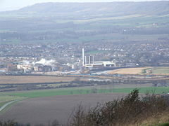
 View over the Medway Gap from Blue Bell Hill with Snodland and the Horseshoe Reach meander of the River Medway with the paper mills in front, and the North Downs behind | |
| جمعیت | ۱۰٬۲۱۱ (2011 Census)[۱] |
| مرجع شبکه OS | TQ699514 |
| منطقه | |
| Shire county | |
| ناحیه | |
| کشور | England |
| کشور مستقل | بریتانیا |
| پست شهر | SNODLAND |
| کدپستی منطقه | ME6 |
| کد تلفن | 01634 |
| مجلس انگلستان | |
اسنودلند (به انگلیسی: Snodland) یک شهرک در بریتانیا است که در انگلستان واقع شدهاست.[۲]
خصوصیات[ویرایش]
اسنودلند ۱۲٬۰۰۰ نفر جمعیت دارد.
نگارخانه[ویرایش]
جستارهای وابسته[ویرایش]
منابع[ویرایش]
- ↑ "Civil Parish population 2011". Neighbourhood Statististics. Office for National Statistics. Archived from the original on 20 اكتبر 2016. Retrieved 24 September 2016.
{{cite web}}: Check date values in:|archive-date=(help) - ↑ مشارکت کنندگان ویکیپدیای انگلیسی. «Snodland».


