پرش به محتوا

پرونده:Vimy Ridge 1917-barrage map.jpg

Page contents not supported in other languages.
از ویکی‌پدیا، دانشنامهٔ آزاد

پروندهٔ اصلی(۱٬۹۶۳ × ۲٬۶۶۲ پیکسل، اندازهٔ پرونده: ۹۲۲ کیلوبایت، نوع MIME پرونده: image/jpeg)

توضیح High Resolution Barrage Map [Showing Boundaries and Objectives for Assault on Vimy Ridge, Scale [1:10,000]
تاریخ Produced 1917
منبع
This image is available from Library and Archives Canada under the reproduction reference number NMC 111113 and under the MIKAN ID number 178448

This tag does not indicate the copyright status of the attached work. A normal copyright tag is still required. See Commons:Licensing.

Library and Archives Canada does not allow free use of its copyrighted works. See Category:Images from Library and Archives Canada.

English  français  македонски  日本語  +/−

پدیدآور Base map supplied by Ordnance Survey,[1] and modified by 1st Field Survey Company, Royal Engineers (as denoted in bottom left quadrant of map)
اجازه‌نامه
(استفادهٔ مجدد از این پرونده)
This work is an Ordnance Survey map over 50 years old, which is covered by Crown Copyright which in this case expires 50 years after publication. Ordnance Survey does however ask that they be credited and that the date of publication be given. Any ancillary rights gained through the creation of the electronic version are granted as freely usable under any circumstances.
Public domain
This work created by the United Kingdom Government is in the public domain.

This is because it is one of the following:

  1. It is a photograph taken prior to 1 June 1957; or
  2. It was published prior to 1974; or
  3. It is an artistic work other than a photograph or engraving (e.g. a painting) which was created prior to 1974.

HMSO has declared that the expiry of Crown Copyrights applies worldwide (ref: HMSO Email Reply)
More information.

See also Copyright and Crown copyright artistic works.

Deutsch  English  Español  français  italiano  Nederlands  polski  português  sicilianu  slovenščina  suomi  Türkçe  македонски  русский  українська  മലയാളം  한국어  日本語  简体中文  繁體中文  العربية  +/−

Public domain
این اثر در ایالات متحده آمریکا در مالکیت عمومی قرار دارد به این دلیل که قبل از ۱ ژانویهٔ ۱۹۲۹ منتشر یا در ادارهٔ حق تکثیر آمریکا ثبت شده‌است.

آثار ماکلیت عمومی می‌بایست خارج از حق تکثیر هم در آمریکا و هم در کشور مبدأ اثر باشند تا بتوانند در ویکی‌انبار قرار بگیرند. اگر اثر، اثر ایالات متحده آمریکا نباشد، پرونده می‌بایست یک برچسپ حق تکثیر اضافی داشته باشند که وضعیت حق تکثیر را در کشور مبدأ مشخص کند.

عنوان

شرحی یک‌خطی از محتوای این فایل اضافه کنید

آیتم‌هایی که در این پرونده نمایش داده شده‌اند

توصیف‌ها

تاریخچهٔ پرونده

روی تاریخ/زمان‌ها کلیک کنید تا نسخهٔ مربوط به آن هنگام را ببینید.

تاریخ/زمانبندانگشتیابعادکاربرتوضیح
کنونی‏۵ ژانویهٔ ۲۰۰۸، ساعت ۱۸:۴۲تصویر بندانگشتی از نسخهٔ مورخ ‏۵ ژانویهٔ ۲۰۰۸، ساعت ۱۸:۴۲۱٬۹۶۳ در ۲٬۶۶۲ (۹۲۲ کیلوبایت)Labattblueboy
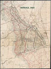
{{Information |Description= High Resolution Barrage Map [Showing Boundaries and Objectives for Assault on Vimy Ridge, Scale [1:10,000] |Source= National Archives of Canada (NMC-111113) |Date= Produced 1917 |Author= 1st Field Survey Company, Royal Engineer

صفحهٔ زیر از این تصویر استفاده می‌کند:

کاربرد سراسری پرونده

ویکی‌های دیگر زیر از این پرونده استفاده می‌کنند:

فراداده